Case study / Drone mission planning

Epoch.
Start with the measurement.

A drone survey should begin with what you need to learn. I built Epoch to turn that goal into a flight plan you can inspect, repeat, and improve.

Python · TypeScript · FastAPI · MapLibre
Local-first application / In development

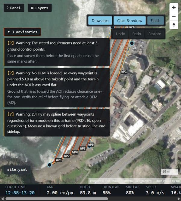
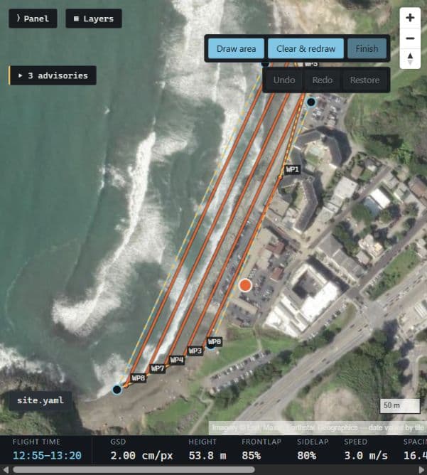
Epoch map of Rockaway Beach with parallel survey passes, numbered waypoints, a launch point, and flight estimates
A proposed Rockaway Beach survey. The map shows the route and estimated capture settings, not a record of a completed flight.

The flight is only useful if it answers the question.

For a repeat coastal survey, drawing a boundary and choosing a flight height is only the beginning. The images need enough detail and overlap to support the measurement, and the next visit needs to be comparable to the last.

Epoch works backward from that need. Instead of choosing settings first and explaining them later, I wanted a tool that could show how each setting follows from the survey goal—and make the assumptions visible.

From survey goal to field plan.

01 / Plan

Keep each visit connected.

Choose a mission, define the area to cover, and state what needs to be measurable. Epoch works out the image detail, height, overlap, and spacing between flight passes. The map makes the resulting route easy to inspect.

Saved versions keep earlier plans available, with a name and a note about what changed. That gives a repeat visit a starting point instead of another set of settings to recreate from memory.
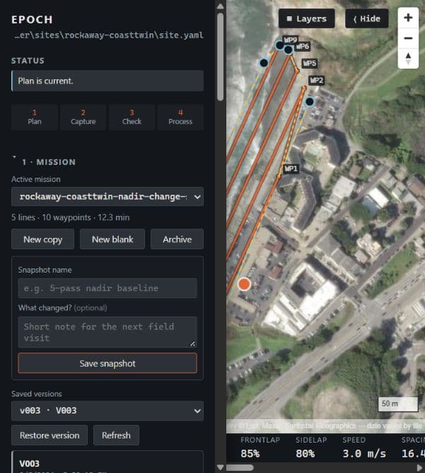
Epoch mission panel showing the Rockaway survey, snapshot controls, and saved mission versions beside the map
The mission library keeps the current survey and earlier versions together.

02 / Capture

Make the numbers useful to the pilot.

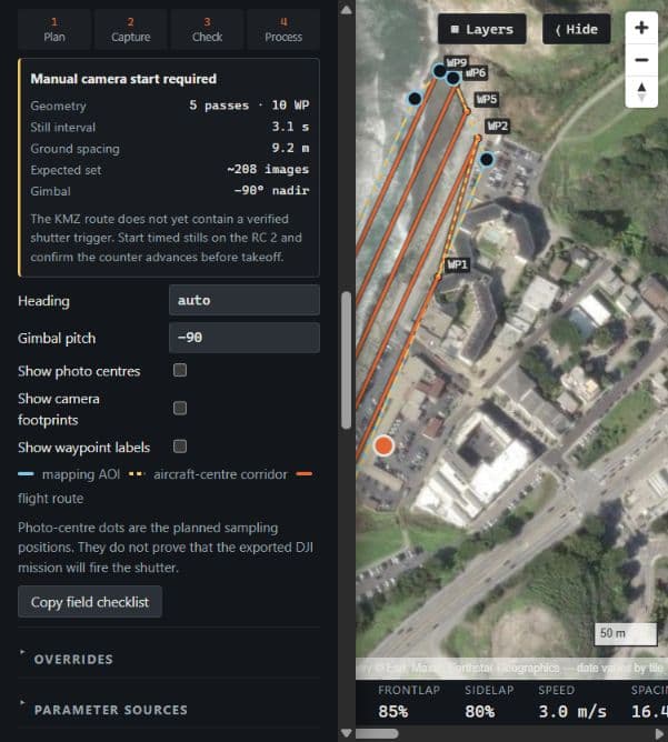
The camera panel brings together the number of passes, photo interval, expected image count, and camera angle. In this example, five passes are expected to produce about 208 images, with a photo roughly every 3.1 seconds.

Those are planning estimates. The interface explicitly says that the route does not yet have a verified shutter trigger. Showing planned photo positions must not imply that the aircraft will automatically take those photos.

Camera and flight panel showing five passes, ten waypoints, a 3.1-second still interval, and a manual camera start warning
Capture settings explain the plan while keeping the unverified shutter behavior visible.

03 / Check

Show what still needs attention.

A plausible-looking route is not enough. Epoch surfaces assumptions that could change the result: missing terrain, ground-control requirements, and uncertainty about how the aircraft turns between waypoints.

The captured plan has no elevation model loaded. Its height is relative to the launch point, so rising ground would reduce clearance. Terrain sampling is supported, but this example makes its absence explicit.

Expanded mission advisories describing ground-control requirements, a missing elevation model, and uncertainty in aircraft turns
Advisories expose the assumptions behind the current plan rather than hiding them behind a ready status.

04 / Process

Connect the plan to the images.

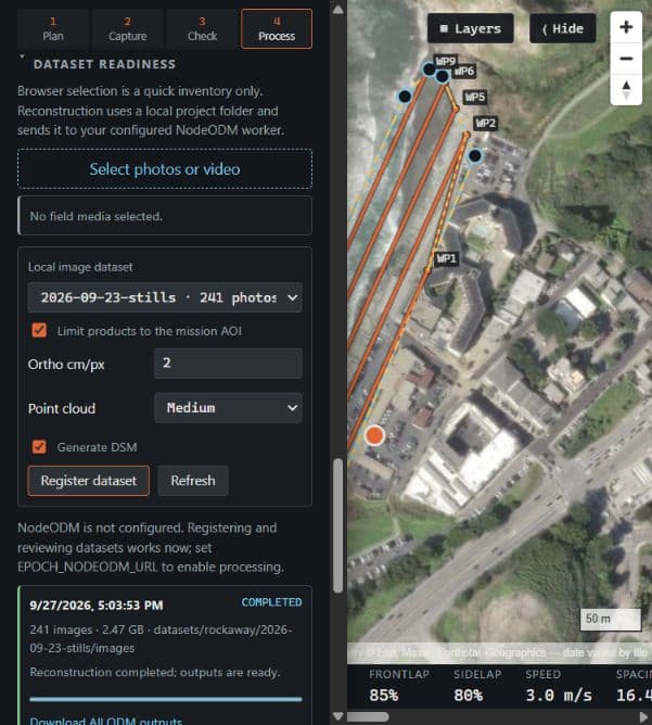
After collection, the processing workspace discovers local image folders and keeps reconstruction settings with the mission. With a NodeODM worker configured, it can submit images to produce a stitched aerial map, a surface model, and a 3D point cloud.

The capture shows a 241-photo dataset and previous completed job records. The current session has no worker configured, so it is not starting a new reconstruction. Flight plans and processing jobs remain separate records.

Processing workspace showing a 241-photo dataset, reconstruction settings, historical completed jobs, and a NodeODM not configured message
Dataset review and processing history, with the current worker connection status visible.

Decisions that make a plan explainable.

One mission, two ways to edit

The map and a plain-text mission file edit the same plan. Browser changes update the file; external edits update the map. If the file becomes invalid, the last good plan stays visible while the error is reported.

A reason behind each setting

Requirements become limits on capture settings. Conflicting requirements raise an error rather than silently overriding one another. Deliberate overrides require a written reason, and the export records where each value came from.

Repeatable exports

The same inputs produce identical mission files. Fixed timestamps and coordinate precision keep incidental differences out of the export, making changes easier to trace between visits.

Calculations separate from connections

The Python planning logic is separated from files, network calls, and the web server. That makes it possible to check geometry and parameter calculations without depending on a map service or controller.

What is working—and what still needs proving.

Epoch brings mission editing, derived flight paths, saved versions, advisories, DJI-format exports, and a processing workflow into a local browser application. The codebase includes checks for repeatable exports and for keeping file and network access outside the planning core.

This case study documents the application workflow, not an end-to-end flight validation. A generated mission still needs inspection on the controller and field verification. Planned resolution is not a demonstrated measurement accuracy; repeat-survey change detection still needs measured results.

The processing interface includes later comparison steps as a roadmap. Their presence is not evidence that an automated, validated change-detection pipeline is complete.

Application captures from the local Rockaway Beach mission. Basemap attribution remains visible in the images. No flight, export, or reconstruction job was initiated for these captures.

← Back to projects